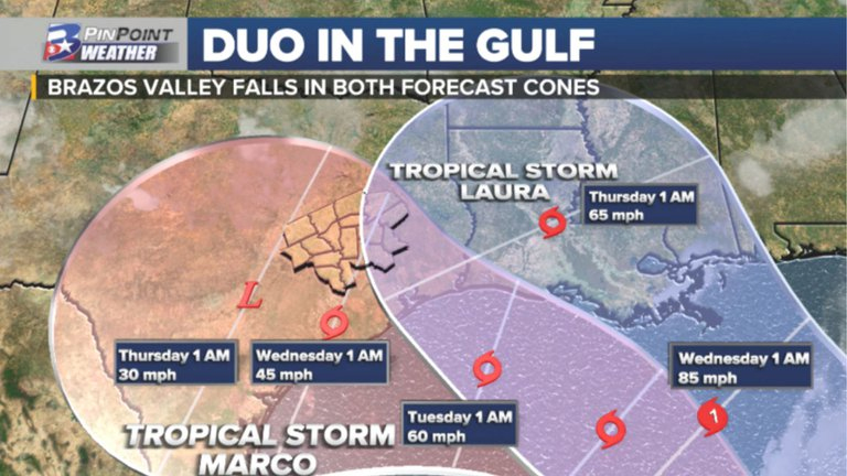
La tormenta Marco cruza el Golfo de México con vientos casi de huracán
EL fenómeno se dirige a los EEUU. Mientras, la tormenta tropical Laura continúa avanzando sobre la isla de La Española, que abarca a República Dominicana y Haití
Marco podría convertirse en huracán hoy en aguas del Golfo de México de camino al sur de Estados Unidos. A las 8:00 hora local (12:00 GMT) su centro fue localizado a unas 210 millas (340 km) al noroeste del extremo occidental de Cuba y a unas 360 millas (580 km) al sur-sureste de la desembocadura del Río Misisipi (EEUU). Los vientos máximos sostenidos están cerca de los 70 mph (110 km/h) con ráfagas mayores, detalla el NHC.
Se prevé que Marco se convierta en un huracán hoy en la tarde y mantenga esa fuerza mientras se acerque el lunes a la costa norte del Golfo de México.
Un debilitamiento rápido es esperado después de que Marco se interne en algún punto del sureste de Luisiana en lunes. Una advertencia de huracán está vigente desde Morgan City (Luisiana) hasta la desembocadura del río Pearl.
Una vigilancia de tormenta tropical por Marco sigue activada desde la frontera de Misisipi con Alabama, hasta la demarcación de este último estado con el de Florida.
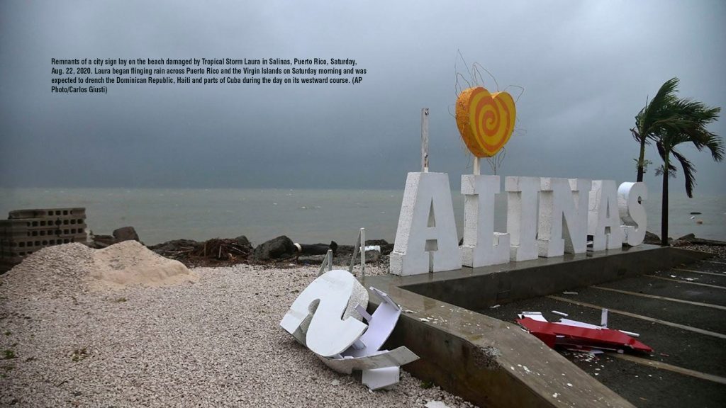
La tormenta tropical Laura continúa avanzando este domingo sobre la isla de La Española, que abarca a República Dominicana y Haití, con lluvias torrenciales que se trasladarán al este de Cuba.
A las 8:00 hora local (12:00 GMT), el centro de Laura se encontraba a unas 40 millas (65 km) al norte-noreste de Puerto Príncipe (Haití) y a unas 50 millas (80 km) al sur de Cabo Haitiano. En el pronóstico de recorrido, Laura, que lleva vientos máximos sostenidos de cerca de 45 millas por hora (75 km/h), moverá su centro a través de La Española durante la jornada de hoy, para acercarse a Cuba entrada la noche, indica un boletín del Centro Nacional de Huracanes (NHC) con sede en Miami (EE.UU.).
Este sistema se mueve en dirección oeste-noroeste a una velocidad de 18 m/h (30 km/h) y está dejando lluvias torrenciales con posibles inundaciones a su paso.
De acuerdo con el NHC, no se pronostica ningún cambio significativo en la fuerza de los vientos de Laura entre las próximas 36 a 48 horas mientras el sistema se traslada a través de La Española hacia Cuba. Sin embargo, se pronostica un fortalecimiento una vez que entre al Golfo de México en la noche del lunes y las primeras horas del martes.
Están vigentes las advertencias de tormenta tropical para la costa norte de la República Dominicana, desde Cabo Engaño hasta la frontera con Haití. También para el sureste de Bahamas y las Islas Turcas y Caicos, y casi toda la isla de Cuba.
Laura ha marcado igualmente una vigilancia de tormenta tropical para las islas centrales de Bahamas, los Cayos de Florida desde Ocean Reef hasta Key West y Dry Tortugas, la Bahía de Florida y la provincia cubana de Pinar Del Río.
Con información de EFE
Marco Expected To Become A Hurricane Today As It Enters The Central Gulf Of Mexico
Tropical Storm
At 1000 AM CDT (1500 UTC), the center of Tropical Storm Marco was located near latitude 24.7 North, longitude 87.3 West. Marco is moving toward the north-northwest near 14 mph (22 km/h), and this motion is expected to continue through tonight, followed by a turn to the northwest by Monday. On the forecast track, Marco will cross the central Gulf of Mexico today and will approach southeastern Louisiana on Monday. A gradual turn toward the west-northwest with a decrease in forward speed is expected after Marco moves inland.
Maximum sustained winds are near 70 mph (110 km/h) with higher gusts. Some strengthening is anticipated and Marco is forecast to become a hurricane later today and be at hurricane strength when it approaches the northern Gulf Coast on Monday. Rapid weakening is expected after Marco moves inland.
Tropical-storm-force winds extend outward up to 70 miles (110 km) from the center.
The estimated minimum central pressure is 993 mb (29.33 inches).
Watches and Warnings
CHANGES WITH THIS ADVISORY:
The Storm Surge Watch has been discontinued from the Mississippi/Alabama border to the Alabama/Florida border, including Mobile Bay.
SUMMARY OF WATCHES AND WARNINGS IN EFFECT:
A Storm Surge Warning is in effect for, . * Morgan City Louisiana to Ocean Springs Mississippi * Lake Borgne
A Hurricane Warning is in effect for, * Morgan City Louisiana to the Mouth of the Pearl River
A Storm Surge Watch is in effect for, * Sabine Pass to Morgan City Louisiana * Ocean Springs Mississippi to the Mississippi/Alabama border * Lake Pontchartrain and Lake Maurepas
A Hurricane Watch is in effect for, * Intracoastal City Louisiana to west of Morgan City * Lake Pontchartrain, Lake Maurepas, and Metropolitan New Orleans
A Tropical Storm Warning is in effect for, * Mouth of the Pearl River to the Mississippi/Alabama border * Lake Pontchartrain, Lake Maurepas, and Metropolitan New Orleans
A Tropical Storm Watch is in effect for, * Mississippi/Alabama border to the Alabama/Florida border
A Storm Surge Warning means there is a danger of life-threatening inundation, from rising water moving inland from the coastline, during the next 36 hours in the indicated locations. For a depiction of areas at risk, please see the National Weather Service Storm Surge Watch/Warning Graphic, available at hurricanes.gov. This is a life-threatening situation. Persons located within these areas should take all necessary actions to protect life and property from rising water and the potential for other dangerous conditions. Promptly follow evacuation and other instructions from local officials.
A Hurricane Warning means that hurricane conditions are expected somewhere within the warning area. A warning is typically issued 36 hours before the anticipated first occurrence of tropical-storm-force winds, conditions that make outside preparations difficult or dangerous. Preparations to protect life and property should be rushed to completion.
A Storm Surge Watch means there is a possibility of life- threatening inundation, from rising water moving inland from the coastline, in the indicated locations during the next 48 hours. For a depiction of areas at risk, please see the National Weather Service Storm Surge Watch/Warning Graphic, available at hurricanes.gov.
A Hurricane Watch means that hurricane conditions are possible within the watch area.
A Tropical Storm Warning means that tropical storm conditions are expected somewhere within the warning area within 36 hours.
A Tropical Storm Watch means that tropical storm conditions are possible within the watch area, generally within 48 hours.
For storm information specific to your area in the United States, including possible inland watches and warnings, please monitor products issued by your local National Weather Service forecast office. For storm information specific to your area outside of the United States, please monitor products issued by your national meteorological service.
Land Hazards
STORM SURGE: The combination of a dangerous storm surge and the tide will cause normally dry areas near the coast to be flooded by rising waters moving inland from the shoreline. The water could reach the following heights above ground somewhere in the indicated areas if the peak surge occurs at the time of high tide,
Morgan City LA to Ocean Springs MS including Lake Borgne, 4-6 ft Sabine Pass to Morgan City LA, 2-4 ft Ocean Springs MS to the MS/AL Border, 2-4 ft Lake Pontchartrain and Lake Maurepas, 2-4 ft MS/AL Border to AL/FL Border including Mobile Bay, 1-3 ft
The deepest water will occur along the immediate coast in areas of onshore winds, where the surge will be accompanied by large and dangerous waves. Surge-related flooding depends on the relative timing of the surge and the tidal cycle, and can vary greatly over short distances. For information specific to your area, please see products issued by your local National Weather Service forecast office.
WIND: Hurricane conditions are expected within the hurricane warning area by midday Monday, with tropical storm conditions possible by early Monday. Tropical storm conditions are possible within the tropical storm watch area on Monday, and hurricane conditions are possible within the hurricane watch areas late Monday.
RAINFALL: Marco is expected to produce rainfall accumulations of 2 to 4 inches with isolated maximum amounts of 6 inches across the Central U.S. Gulf coast through Tuesday.
This rainfall may result in isolated areas of flash and urban flooding along the Central U.S. Gulf Coast.
SURF: Swells generated by Marco are likely to affect portions of the northern Gulf Coast later today. These swells are likely to cause life-threatening surf and rip current conditions. Please consult products from your local weather office.
TORNADOES: An isolated tornado will be possible early Monday morning near the southeast Louisiana coast. By https://www.click2houston
 (1) (2).jpg)


Debe estar conectado para enviar un comentario.