Tormenta tropical Claudette toca tierra en norte del Golfo de México
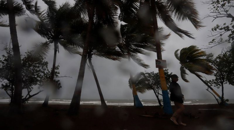
MIAMI.- Un sistema de bajas presiones se convirtió este sábado en Claudette, la tercera tormenta tropical de este año en la cuenca atlántica, poco antes de impactar con la costa estadounidense del Golfo de México con vientos de 45 millas por hora (75 kilómetros por hora).
Según el último boletín del Centro Nacional de Huracanes (NHC) de Estados Unidos, emitido a las 8.00 hora local (12.00 GMT), señala que Claudette tocó tierra en el sureste del estado de Louisiana, donde deja ya fuertes lluvias.
A esa hora, el sistema de bajas presiones se encontraba a unas 30 millas (45 kilómetros) al norte de Nueva Orleans y tenía rumbo nornoreste con una velocidad de traslación de 12 millas por hora (19 km/h).
Eso hará que Claudette avance hacia el interior de los Estados Unidos, lo que provocará que pierda su fuerza de manera paulatina hasta salir a inicios de la próxima semana por la costa este, a la altura de Carolina del Norte, donde podría retomar intensidad de nuevo mientras se dirige hacia las frías aguas del Atlántico norte.
Los expertos alertan a la población de que no deben guiarse de la trayectoria prevista de este ciclón pues, debido a su estructura dispersa, los peligros que suponen sus lluvias y fuertes vientos se notarán una zona muy extensa al este de su centro y la costa norte del Golfo de México.
Piden prestar especial atención al riesgo de inundaciones en la costa de Mississippi, Alabama y el extremo oeste de Florida este sábado, peligro que se extenderá el domingo hacia el noreste y partes interiores del sureste del país.
Se espera que Claudette produzca precipitaciones totales de 5 a 10 pulgadas (12,7 y 25,4 centímetros) con cantidades máximas aisladas de 15 pulgadas (38 centímetros) en zonas de la costa central del Golfo de México.
La combinación de marejada ciclónica y marea puede hacer que se inunden zonas costeras y hay riesgo de tornados en Mississippi, Alabama, oeste de Florida y Georgia.
Este año se han formado ya las tormentas «Ana» y «Bill» en la cuenca atlántica, ambas de escasa duración y poco dañinas. EFE
Tropical Storm Claudette makes landfall on the northern coast of the Gulf of Mexico
A low pressure system became this Saturday in Claudette, the third tropical storm this year in the Atlantic basin, shortly before hitting the US coast of the Gulf of Mexico with winds of 45 miles per hour (75 kilometers per hour).
ALSO READ: British adviser says third wave of covid-19 “is on the way”
According to the latest bulletin from the United States National Hurricane Center (NHC), issued at 8.00 local time (12.00 GMT), notes that Claudette made landfall in southeastern Louisiana, where it is already leaving heavy rains.
At that time, the low pressure system was about 30 miles (45 kilometers) north of New Orleans and was heading northeast with a translation speed of 12 miles per hour (19 km / h).
That will move Claudette into the interior of the United States, This will cause it to gradually lose its strength until it leaves early next week on the east coast, off North Carolina, where it could resume its intensity again as it heads towards the cold waters of the North Atlantic.
Experts warn the population that they should not be guided by the expected trajectory of this cyclone because, due to its dispersed structure, the dangers posed by its rains and strong winds, a very large area east of its center and the north coast will be noticed. of the Gulf of Mexico.
They ask to pay special attention to the risk of flooding on the coast of Mississippi, Alabama and the extreme west of Florida this Saturdayor, danger that will spread to the northeast and interior parts of the southeast of the country on Sunday.
Claudette is expected to produce total rainfall of 5 to 10 inches (12.7 and 25.4 centimeters) with isolated maximum amounts of 15 inches (38 centimeters) in areas of the central coast of the Gulf of Mexico.
The combination of storm surge and tide can cause coastal areas to flood and there is a risk of tornadoes in Mississippi, Alabama, western Florida and Georgia.
This year the storms “Ana” and “Bill” have already formed in the Atlantic basin, both of short duration and little damage.
 (1) (2).jpg)